 Expand
Most of us won't ever visit space. But space has been brought to
us, in the form of images and data collected for years by spacecraft,
satellites and telescopes. Here are the 10 best online, interactive apps
that allow you to explore space from your computer. Grab your mouse,
Ensign — you have the helm.
1) Eyes On The Solar System
 Expand
Flying from planet to planet, I pause to admire the view of Phobos passing across the face of Mars. (Whoa.) JPL's stunning 3D visualization—which requires you to download a free app—allows you to explore the solar system
both in time and space. You can pick any date between 1949 and 2049,
which is an especially useful feature if you choose to do a "ride along"
with an historical spacecraft. When I select "Pioneer 10" from the
destination menu and choose "Jupiter flyby," it's suddenly December 3,
1973 and I'm hovering next to a 3D model of the probe, 617,000 miles
from its destination and closing.
2) The Lunar Northern Polar Mosaic
 Expand
Arizona State University, which developed the Lunar Reconnaissance Orbiter
Camera
(LROC), has assembled 10,581 images, collected over four years, to create
this spectacular northern polar mosaic of the Moon's surface.
According to ASU, this is "likely one of the world's largest image
mosaics in existence, or at least publicly available on the web, with
over 680 gigapixels of valid image data covering a region of the Moon
(0.98 million sq. miles) slightly larger than the combined area of
Alaska and Texas — at a resolution of 2 meters per pixel!"
 Expand
That level of detail is apparent as you
click
and zoom your way around sites on the lunar surface. Every rock, groove
and shadow is visible, such as this image (above) of the tracks made by
a boulder rolling down the central peak of Hayn crater.3) The Billion-Pixel View From Curiosity at Rocknest
I've seen quite a few interactive views of Mars, but in terms of detail my favorite is
this one
created by JPL. It's a scaled-down version of a full-circle view that
combines nearly 900 images taken by NASA's Curiosity Mars rover. The
view is centered toward the south, with north at both ends. It shows
Curiosity at the "Rocknest" site where the rover scooped up samples of
windblown dust and sand. Curiosity used three cameras to take the
component images on several different days, between Oct. 5 and Nov. 16,
2012.
 Expand
One version of the panorama has been white-balanced to show what the
scene would look like under Earth lighting conditions, which is helpful
in distinguishing and recognizing materials in the rocks and soil. You
can also opt for the "raw color" version, which shows illumination
effects from variations in the time of day.
You can pan and zoom across either a cylindrical or panorama view. I
recommend panorama, since it offers the option of seeing the
breathtaking landscape in full-screen mode.
4) The First Men on the Moon
Among the many apps and websites that were created to commemorate the
45th anniversary of the Apollo 11 lunar landing, this one is a standout.
The First Men on the Moon recreates Eagle's descent,
using spaceflight video footage, communication audio, mission control
room conversations, text transcripts and telemetry data.
 Expand
The result is a meticulously synchronized audio-video presentation. It
begins with hearing the words of Buzz Aldrin, while simultaneously
viewing the moon through the lunar module window. Moments later, you
hear capsule communicator Charlie Duke inform flight director Gene Kranz
that the astronauts are on schedule to start the descent engine.
Throughout the simulation you can jump to key moments in the timeline,
including computer alerts, the "Go/No Go" polls in the control room and,
finally, the landing itself. It's a front row seat to history… and it's
a nailbiter.
5) Interactive ISS Photo Map
 Expand
I recently wrote about this visualization, but it's well worth a second
mention. Dave MacClean, a faculty member at the Centre of Geographic
Sciences in Nova Scotia, created
an interactive world map of more than 650 pictures that the astronauts aboard the International Space Station have shared on
Twitter
.
Each locator pin is color-coded to indicate which astronaut took the
photo. Just left-click on the pin to see the image and a link to the
original tweet. And, as a bonus, the map shows you the location of the
space station in real time (give or take a minute).
6) The Scale of the Universe
This
interactive flash animation is a stunning, modern version of the classic video Powers of Ten.
Moving the toggle takes you from the edge of the observable universe
and through distant galaxies until you arrive at Earth, and continue
your voyage through inner space to the sub-atomic level. Along the way,
clicking on individual items brings up descriptive information.
7) Eyes on the Earth
 Expand
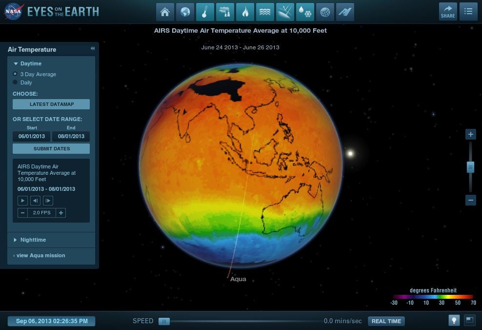
Another amazing 3D visualization that uses NASA's "Eyes On" app, this one allows you to view the space agency's fleet of Earth observation satellites
in real time. Click on any satellite to go on a virtual fly along and
learn more about its mission. A menu lets you see different versions of
the Earth — carbon dioxide levels, global temperature, etc. — created
from data collected by the instrumentation aboard the satellites.
8) Spacewalk
Spacewalk
sticks you in a spacesuit to navigate and explore a richly detailed
recreation of the International Space Station. Patience is a virtue here
— thrusting too fast sent me spinning head over heels (does a spacesuit
have heels?), until I collided with one of the modules.
There's a "multiplayer" option—though, honestly, I'm not sure what you
would do with other players other than wave at them, or perhaps play an
orbital version of bumper cars.
Spacewalk has recently been optimized for use with Oculus Rift, but you can still download the original version. It's a wild ride.
9) Orbital Objects
It's
getting awfully crowded up there. In addition to the more than 1,000
active satellites that are orbiting the Earth, more than 21,000 pieces
of orbital debris larger than 10 cm are known to exist. These pieces of
space junk collide with each other, generating additional debris in the
form of high-velocity fragments that can travel as fast as 35,000 miles
per hour.
 Expand
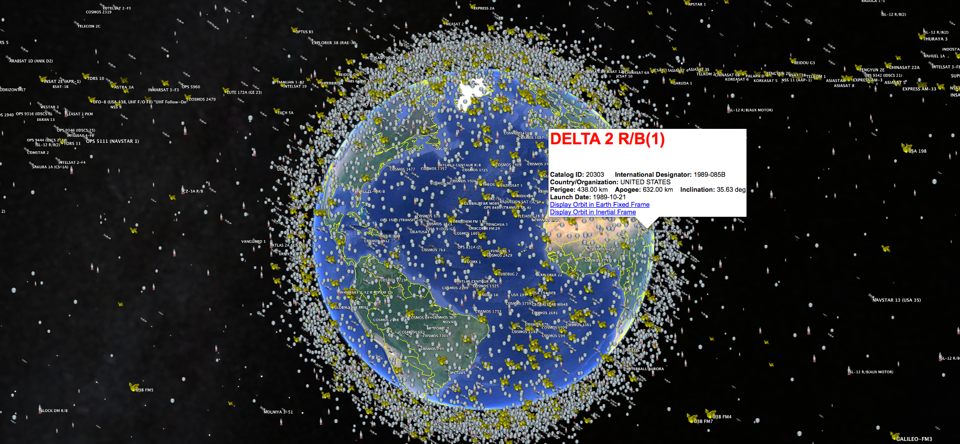
You can pay a virtual visit to our orbital junkyard,
courtesy of this interactive, 3D visualization (image above) made by
Alex Rasmussen. Points marked in green represent active satellites.
Points marked in gray are inactive satellites that are still intact.
Points marked as red are tracked pieces of space debris.
Orbital Objects is best viewed on Google Chrome. Use up and down arrows to zoom in and out, and the mouse to rotate.
 Expand
Another visualization currently under development by Satellite Spy uses the Google Earth plugin to map thousands of near-Earth objects (above). Click on each one to identify the piece of space debris and its source.
10) Eyes on Exoplanets
The most recent—and most astonishing—addition to NASA's "Eyes On" series takes you 1,000 light years away from Earth to
explore the stars
in our galactic neighborhood. The data used to create the simulation
includes 1,061 stars with known exoplanets—1,743 exoplanets to be
precise.
 Expand
Click on a star to zoom in. A menu of options includes a visualization
of the star's habitable zone and an onscreen comparison with our own
solar
system. Remember that awesome "stellar cartography" room (above) aboard the USS Enterprise in
Star Trek: Generations? You now have it on your desktop.extracted by io9.com All rights owned by them.